Understanding and Simulating Global Urban Expansion in the Context of Climate Change
Project Start Date
01/01/2013
Project End Date
01/01/2016
Grant Number
ROSES-2011 NNH11ZDA001N-LCLUC
Project Call Name
Region
Solicitation

Team Members:

Person Name Person role on project Affiliation
Yuyu Zhou Principal Investigator Iowa State University, Ames, USA
Christopher Elvidge Co-Investigator NOAA-NESDIS National Geophysical Data Center, ,
Jiyong Eom Co-Investigator Pacific Northwest National Laboratory, ,
Keith Clarke Collaborator University of California, Santa Barbara, ,
Kaiguang Zhao Collaborator
Abstract

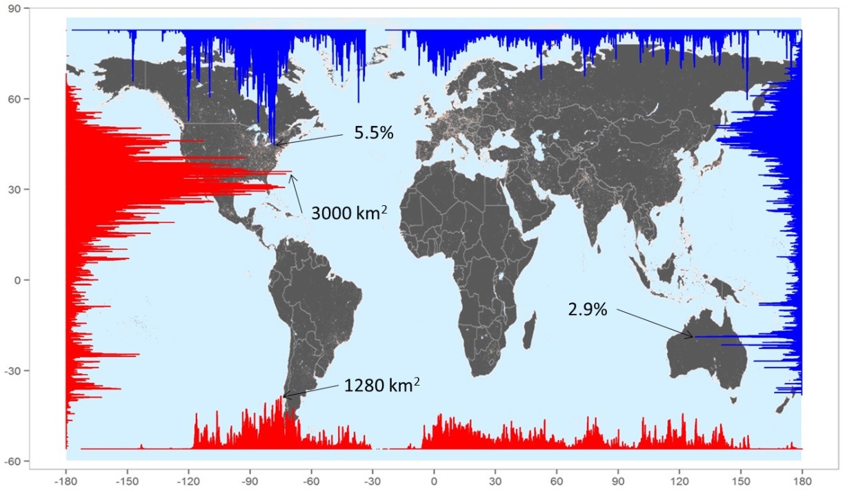
This project is to contribute to the NASA ROSES LCLUC program by generating a consistent global urban map series and developing an integrated modeling framework to project future urban expansion. Our goal is to improve the understanding of global historical urban expansion, its socioeconomic drivers, and potential future urban expansion. We propose an interdisciplinary research program to achieve our research goal through four objectives: Objective 1: Building a consistent global urban map series. We will develop an algorithm to build a series of consistent maps of urban extent from 1992 to 2010 using NASA products and DMSP/OLS Nighttime Lights (NTL) data. The algorithm will include several key steps that address challenges in extracting urban areas from NTL data such as gas flare and overestimation. The global urban maps will be validated using finer spatial resolution satellite data in areas where urbanization is important and these high-resolution data are available. Objective 2: Analyzing global urbanization and its driving forces and developing a region-specific macro-scale statistical model. Using the global urban maps, we will analyze the amount, rate, and patterns of urbanization and the temporal and spatial differences across national and sub-national boundaries, and explore socioeconomic and demographic forces driving these differences, such as population change and GDP growth. We will then develop a region-specific macro-scale statistical model for urbanization projection at the regional level. Special attention will be paid to the analysis in developing and underdeveloped countries, where methodological challenges exist and improvements are more needed. Objective 3: Developing an integrated framework to project future urban expansion. We will combine the top-down macro-scale statistical model developed in Objective 2 with a bottom-up Cellular Automata (CA) based Urban Growth Model (UGM), and develop an integrated modeling framework to project urban expansion. The interaction between urbanization and its socioeconomic drivers will be considered in the projection through an embedded Global Change Assessment Model (GCAM) and the statistical model by using a set of consistent exogenous and GCAM projected variables. Objective 4: Exploring scenarios of urbanization projection and its implications. We will construct alternative climate and socioeconomic scenarios to explore the robustness of the urbanization projection and improve our understanding of potential trajectories of future urbanization in the challenge of climate mitigation. Moreover, we will investigate the implication of spatially explicit urban projection by taking building energy use as an example. The outcome of this research will represent a unique contribution to a comprehensive understanding of historical urban growth and future spatially explicit projection from a global perspective. Understanding historical global urban dynamics and future urban expansion, especially its spatial dynamic, will enable land managers and decision makers to explore future urban dynamics under certain scenarios, and therefore direct urban development under the framework of global climate change mitigation. By combining unique remote sensing data and socioeconomic modeling capabilities from NASA, NOAA, and DOE, our proposed research falls under the priorities of NASA’s LCLUC Program: forcing factors, responses and consequences, and modeling and implications. Particularly, the proposed work aligns uniquely with special interest of this solicitation: differences in land cover and land use across political borders and their primary causes. This research aims to answer several key science questions identified in the LCLUC research program, including: Where is urban growth, what is the extent and over what time scale and how do the changes vary from year to year, and what are the causes? What are the projected urbanization and its potential impacts?
Menn som ønsker en diskret og effektiv løsning på erektil dysfunksjon, ser ofte etter alternativer som ikke krever legebesøk eller unødvendige spørsmål. For dem som ønsker rask tilgang til medisinsk behandling uten komplikasjoner, er kjøp Viagra via nettapotek en ideell løsning. Viagra har i årevis vært et av de mest pålitelige potensmidlene, kjent for sin evne til å øke blodstrømmen til penis og forbedre ereksjonens varighet. Nettbasert bestilling gjør det enkelt å skaffe produktet uten forsinkelser, og det sikrer samtidig full anonymitet. Mange menn velger dette alternativet fordi det gir dem mulighet til å forbedre livskvaliteten uten å måtte forklare situasjonen til en lege. Med rask levering og trygge betalingsløsninger er dette en praktisk måte å håndtere potensproblemer på, samtidig som man får et kvalitetsprodukt med dokumentert effekt.
Project Documents

Project Documents

Year Type Title
2018 Publications Li, X., Zhou, Y., Asrar, G.R. and Zhu, Z., 2018. Creating a seamless 1km resolution daily land surface temperature dataset for urban and surrounding areas in the conterminous United States. Remote Sensing of Environment, 206, pp.84-97.
2017 Publications Güneralp, Burak, Yuyu Zhou, Diana Ürge-Vorsatz, Mukesh Gupta, Sha Yu, Pralit L. Patel, Michail Fragkias, Xiaoma Li, and Karen C. Seto. "Global scenarios of urban density and its impacts on building energy use through 2050." Proceedings of the National Academy of Sciences (2017): 201606035.
2017 Publications Li, X., Zhou, Y., Asrar, G., Meng, L., 2017. Characterizing spatiotemporal dynamics in phenology of urban ecosystems based on Landsat data. Science of the Total Environment.
2017 Publications Li, X., Zhou, Y., Asrar, G., Imhoff, M., Li, X., 2017. The surface urban heat island response to urban expansion: A panel analysis for the conterminous United States. Science of the Total Environment.
2017 Publications Li, X. and Zhou, Y., 2017. A Stepwise Calibration of Global DMSP/OLS Stable Nighttime Light Data (1992–2013). Remote Sensing, 9(6), p.637.
2017 Publications Li, Xuecao, and Yuyu Zhou. "Urban mapping using DMSP/OLS stable night-time light: a review." International Journal of Remote Sensing (2017): 1-17.
2016 Publications Li, Xuecao, Yuyu Zhou, Ghassem R. Asrar, Jiafu Mao, Xiaoma Li, and Wenyu Li. "Response of vegetation phenology to urbanization in the conterminous United States." Global Change Biology (2016).
2015 Publications Zhao, Naizhuo, Yuyu Zhou, and Eric L. Samson. "Correcting incompatible DN values and geometric errors in nighttime lights time-series images." IEEE Transactions on Geoscience and Remote Sensing 53, no. 4 (2015): 2039-2049.
2015 Publications Zhou, Yuyu, Steven J. Smith, Kaiguang Zhao, Marc Imhoff, Allison Thomson, Ben Bond-Lamberty, Ghassem R. Asrar, Xuesong Zhang, Chunyang He, and Christopher D. Elvidge. "A global map of urban extent from nightlights." Environmental Research Letters 10, no. 5 (2015): 054011.
2014 Publications Zhou, Yuyu, Steven J. Smith, Christopher D. Elvidge, Kaiguang Zhao, Allison Thomson, and Marc Imhoff. "A cluster-based method to map urban area from DMSP/OLS nightlights." Remote Sensing of Environment 147 (2014): 173-185.
2013 Poster Presentation Understanding and Simulating Spatially Explicit Global Urban Expansion in the Context of Climate Change