Land Use Science in Action

CONTINUED FOREST PROTECTION MUST BE CORE TO COMMUNITY DEVELOPMENT
- Marginal lands are now being used for crop production to feed an ever-growing population.
- Agriculture productivity must increase to meet demand, intensification rather than intensification.
- Currently, an urgent need exists for information to maximize yield based on land capabilities to mitigate land degradation, improve productivity, and to alleviate food insecurity.
- NASA's role in Earth observation is essential for merging cutting-edge modeling with very high-resolution commercial data to inform the sustainability of current land use and food security.
- Long-term effects of a lack of land tenure rights can be addressed with multi-resolution remote sensing data to relieve land pressure and move toward sustainable management practices.
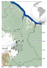
Village Sustainable Planning and its influence on tropical forestry outcomes in Guyana
CONTINUED FOREST PROTECTION MUST BE CORE TO COMMUNITY DEVELOPMENT
- Carbon payment mechanisms to incentive sustainable forest management have an impact on forest loss
- Analyses integrating remote sensing and socioeconomic data can quantify the effectiveness of Village Sustainability Planning program on forest and land use
- With the rise carbon payment mechanisms for forest conservation, urgent need for such analyses is needed to inform current and future sustainable planning
- NASA’s role in Earth observation is essential for measuring and monitoring global investments in carbon markets
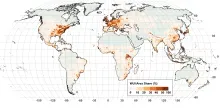
The global wildland-urban interface
A systematic assessment of global areas of potential direct human-environmental conflict
- The wildland-urban interface (WUI) is where houses and wildland vegetation meet.
- The WUI is an area of human-environmental conflict such as wildfire.
- Our new analysis mapped the WUI globally at 10-m resolution from satellite data.
- The WUI covers 4.7% of the global land and is home to half the global population.
- WUI hotspots on all continents in including the US, Eastern Africa, and South-East Asia.

COMMERCIAL SATELLITE MADE IT POSSILE TO EXTRACT FIELDS IN SMALLHOLDER REGIONS
- Crop field boundary is an essential agricultural variable, and crop field sizes are indicative of the degree of agricultural capital investment, mechanization, and labor intensity.
- Information on delineated field boundaries and field sizes are needed for land use planning, allocation of resources, and agricultural modeling.
- Field extraction is extremely challenging in smallholder regions in Asia and Africa due to small field sizes, irregularly-shaped boundaries, narrow margins, and heterogeneities within and across fields.
- With commercial high-resolution images provided by NASA and new computer-vision algorithms, crop field boundaries are produced in smallholder regions in multiple countries in Asia.
- Agrarian transitions are studied based on characterization of field/farm size changes in multiple Asian countries.
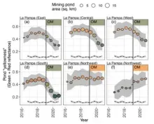
OPERATION MERCURY CURTAILS ILLEGAL MINING IN PROTECTED AREAS TEMPORARILY
- Alluvial gold mining threatens protected conservation and indigenous lands in the tropical Amazon, particularly in Southeastern Peru.
- Federal Military Intervention Actions by the Peruvian government attempted to minimize these activities and move miners to sanctioned mining zones.
- Analyses using remote sensing data can help assess the results of this major policy action.
- NASA’s archival and ongoing data are essential for these conservation policy analyses.
- Peru’s federal policy actions reduced mining in protected areas, shifted mining into buffer unprotected zones, but there is evidence of re-mining activity as enforcement waned.